AboutTermsPrivacyContact
 
Updating
Pilots Atlas

Pilots Atlas

Released: 2013-07-23
© 2020 absoluteZero multimedia GmbH
Pilots Atlas - QR Code
Version 5.8.2
4+
Download on the App Store
Version 5.8.2
4+
Download on the App Store
Released: 2013-07-23
© 2020 absoluteZero multimedia GmbH

iPhone Screenshots

Screenshot
Screenshot
Screenshot
Screenshot
Screenshot
Screenshot
Screenshot
Screenshot
Screenshot
Screenshot

iPad Screenshots

Screenshot
Screenshot
Screenshot
Screenshot
Screenshot
Screenshot
Screenshot
Screenshot
Screenshot
Screenshot

Description

Our famous Pilots “Free Flight” Atlas. Founded in 1998 as an App for iPhone and iPad.
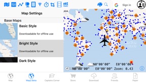
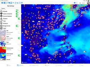
Detailed mapping with selectable aeronautical overlays.
Create your charts with the information you choose. Add positions and notes and share with friends and colleagues.
Now increased functionality and global coverage to offer you an enhanced solution with just the right mix of land and sky with custom tailored charts and information.
Create your own map style, many different map layers and different databases (aeronautical / navigation-aids and Points of Interest´s etc.). Insert, store and/ or edit your flight planed route by using ICAO/ IATA-codes, waypoints, VOR´s NDB´s or Lat/ Long. Find positions with a separate Lat/ Long finder.
Insert and save your destination favorites, create trips, waypoints or notes directly on the map. Implement screen shots from your online-map into the offline-map.
- Contour level by color (meter + feet).
- 185,000 Waypoints (three different types)
- 24,000 Airports (three different types)
- 75,000 Nav-aid´s (VOR-DME, NDB, TACAN, VORTAC, ILS-DME)
- 10,000 POI´s ( points of interest)
- FIR Boundaries
- Special Use Airspace areas (SUAs)
- ADS-B GDL90, SBS1 and online
- topographical maps
- Trip planning (by Waypoints, VOR´s, airports, NDB´s, ICAO/ IATA codes or Lat/ Long).
- Share, copy, invert or export your trip, delete/ edit single trip-points or whole trips. The whole triplength is shown and also the distance between single trip-points.
- Show all your trips (or select your specials) in the map by different colors.
- many different charts on board: planning chart, offline OSM maps and online MapBox maps, NASA Satellite today and yesterday and NASA City Lights.
- Airports, Runway length, elevation, ICAO/ IATA, airport-name, city-name, Lat/ Long, frequencies, magnetic variation and much more
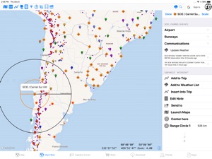
- Create range-circles around airports
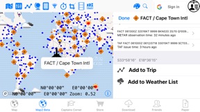
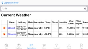
- METAR + TAF are available by clicking on the airport-icon and you can create/edit your own weather-list (along your trip/route).
- connect an external GPS
- delete and re-download the areas you need whenever you like.
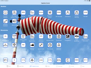
Captains Corner reference stuff:
- Aviation Converter / Calculator: (temp., mass, area, volume, energy, speed power, pressure, length, force..)
- Weather symbols
- Turbulence
- VOLMET table
- SNOWTAM decoder (Notam + Metar)
- MEATAR decoder
- Aircraft country table (Capital city, reg.-code, ISO-code, dialing-prefix, time zone)
- ICAO prefix table
- Thumb rules
- Volcano warning
- Aeronautical abbreviations
- Morse codes
- Airport category
- Operating minima
- Operating minima CAT I + II
- Climb rate
- Jet fuel calculator
- Airport directory
- Nav-aid directory
- Waypoint directory
- Points of interest (POI) directory
- TAF decoder
- IATA delay codes
- Dangerous goods
- Military Interception signalling
- Military MEATAR color codes
- ACARS frequencies
- Airline ICAO-codes
- Flag Gallery worldwide
- Wind chill calculator
Additional weather-overlay as an InApp-Subscription: 1-month free trial.
The Weather-Layer is an yearly auto renewing in-App- Subscription for 3.99 USD with 30 days free trial.
Payment will be charged to iTunes Account at confirmation of purchase.
Subscription automatically renews unless auto-renew is turned off at least 24-hours before the end of the current period.
Any unused portion of a free trial period, if offered, will be forfeited when the user purchases a subscription to that publication, where applicable.
Account will be charged for renewal within 24-hours prior to the end of the current period, and identify the cost of the renewal.
Subscriptions may be managed by the user and auto-renewal may be turned off by going to the user's Account Settings after purchase.
Continued use of GPS running in the background can dramatically decrease battery life.
privacy policy: https://www.absolutezero.de/privacy/index.html
terms of use: https://www.absolutezero.de/index.php/terms-of-use-2

What's New in Version 5.8.2

Database updates.
Choose from multiple label-language options when using the online maps.
Optional Cloud Sync and sync to second devices. Use two devices in parallel. E.g. your iPhone and iPad.
Editing of Trips got reworked, drag&drop-support.
Notes and Images on the map.
Login with AppleID, Google, Facebook and others.
reduced background power consumption.
Some bugfixes and speed improvements..

Seller

Name

absolutezero multimedia GmbH

Information

Categories

Version

5.8.2

Size

635.6 MB

Game Center

No

VPP Device Licensing

Yes

Rating

Rated: 4+

Compatibility

iOS 13.0 or later

Devices

iPhone 5s, iPhone 6, iPhone 6 Plus, iPhone 6s, iPhone 6s Plus, iPhone SE, iPhone 7, iPhone 7 Plus, iPhone 8, iPhone 8 Plus, iPhone X, iPhone XR, iPhone XS, iPhone XS Max, iPhone 11, iPhone 11 Pro, iPhone 11 Pro Max, iPhone SE (2nd generation), iPad (5th Generation) Wi-Fi, iPad (5th Generation) Wi-Fi + Cellular, iPad (6th generation) Wi-Fi, iPad (6th generation) Wi-Fi + Cellular, iPad Pro, iPad Pro (Cellular), iPad Pro (9.7-inch), iPad Pro (9.7-inch) (Cellular), iPad Pro 12.9-inch (2nd generation), iPad Pro 12.9-inch (2nd generation) Wi-Fi + Cellular, iPad Pro (10.5-inch), iPad Pro (10.5-inch) Wi-Fi + Cellular, iPad Pro (11-inch), iPad Pro (11-inch) Wi-Fi + Cellular, iPad Pro 12.9-inch (3rd generation), iPad Pro 12.9-inch (3rd generation) Wi-Fi + Cellular, iPad Air, iPad Air (Cellular), iPad Air 2, iPad Air 2 (Cellular), iPad Air (3rd generation), iPad Air (3rd generation) Wi-Fi + Cellular, iPad mini Retina, iPad mini Retina (Cellular), iPad mini 3, iPad mini 3 (Cellular), iPad mini 4, iPad mini 4 (Cellular), iPad mini (5th Generation), iPad mini (5th Generation) Wi-Fi + Cellular, iPad (7th generation) Wi-Fi, iPad Pro 11-inch (2nd generation), iPad Pro 11-inch (2nd generation) Wi-Fi + Cellular, iPad Pro 12.9-inch (4th generation), iPad Pro 12.9-inch (4th generation) Wi-Fi + Cellular, iPod touch (6th Generation), iPod touch (7th generation)

Languages

English

App Store: Customer Ratings

Ratings & Reviews

3.0 of 5 (13 Ratings)

App Store: Customer Reviews

2017-05-14

Can't Zoom In

I use to always buy the actual books, they are great!
But this app is useless in map or airplane mode I find. You can't zoom in at all. I can't get any detail of what I'm looking at.
I hope the developer corrects this problem as I already paid for the subscriptions.
RB211B757
Version 3.4.0
2014-06-26

Zero "Points of Interest"

This app has ZERO... “Points of Interest” descriptors. Zero.
It does not behave anywhere near it’s description. Disappointing, an expensive lesson.
Astroratings
Version 2.0
2014-02-19

Very buggy

Thought this would be a great app. Started out ok but has now become unusable. Can no longer create trips as the trip window becomes solid black when opened as opposed to opening with data entry boxes.
All my previously created waypoints have dropped the names.
Can not enter ICAO flt plan
Basically a good idea , but VERY poor execution
Waste of the $28 dollar download of Asia map.
Feeling very taken !
Grproude
Version 1.6.0
2013-12-29

Nothing like paper version

Very expensive app. I purchased this app hoping to have a electronic version of their excellent paper Pilots Atlas product. The maps are poor quality with little detail.
RV14 Flyer
Version 1.5.2
2013-11-11

Nice App but a few suggestions:

This app is very handy however the trip waypoint list when selected doesn't always open up displayed. It occasionally opens only to a black screen and cannot easily be reset.
Also the online zoom detail would be great to save and view offline like google maps.
Serving the King of kings.
Version 1.4